
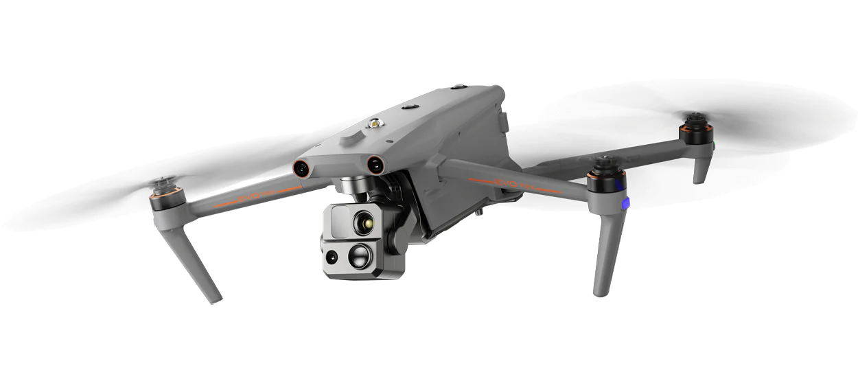
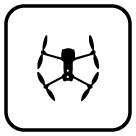
Autel EVO Max 4T - A Leader of Drone Intelligence
The EVO Max 4T brings powerful technologies and advanced autonomy to users. EVO Max 4T assesses complex environments to create real-time 3D flight paths for unparalleled obstacle avoidance.Advanced sensors make flight in GPS unavailable areas possible and the incredible new thermal payload unlocks new object identification and tracking scenarios.With a foldable, weather-resistant design, the EVO Max 4T is as portable as it is capable.

15s
Take Off
Navigation In GPS
Denied Environments

8K 10x
Optical Zoom

12.4 miles
Transmission Range

IP43
Weather Rating
42 mins
Max. Flight Time

Hot-Swappable
Batteries
720° Obstacle
Avoidance
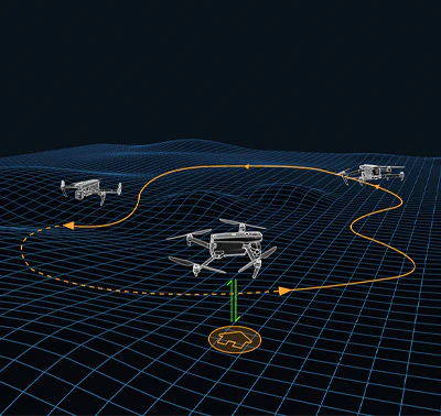
Autonomous Path Finding
Autel's Autonomy Engine collects surrounding environmental data and plans 3D flight paths through complex environments such as mountains, forests, and buildings. Use cases include rapid 3D scene reconstruction, public safety overwatch, industrial inspection, and land surveying.
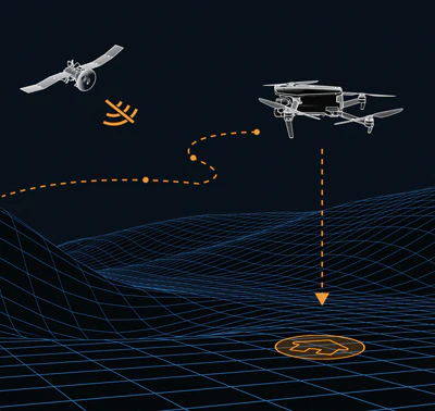
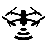
Navigation in GPS Denied Environment
Advanced sensors allow the EVO Max 4T to navigate within hardened structures, underground, or in environments without GPS.
Accurate Object
Identification and Tracking
Based on Autel's AI recognition technology, the EVO Max 4T can automatically identify and lock onto different types of targets such as heat sources, moving people, or vehicles and achieve high-altitude tracking and data collection for law enforcement.
No Blind Spots
Ultimate Obstacle Avoidance
EVO Max 4T is the only commercial drone that combines traditional binocular vision systems with millimeter wave radar technology. This allows the EVO Max 4T's onboard Autel Autonomy Engine to perceive objects down to 0.5 inch, eliminating blind spots and enabling operation in low light or rainy conditions.
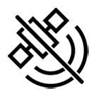
Anti Jam, Anti Interference
The EVO Max 4T uses advanced flight control modules and algorithms specially designed to counter RFI, EMI, and GPS spoofing. This enables the EVO Max 4T to fly confidently near power lines, critical structures, and in complex areas.
Weather Rating-IP43

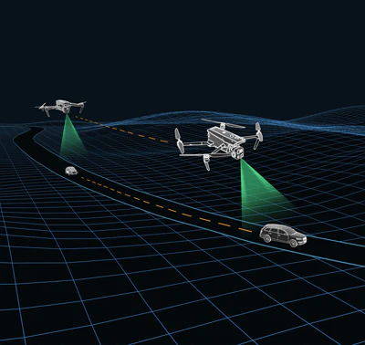
A-Mesh 1.0
The Drone Industry's First Mesh Networking Technology
EVO Max 4T features the new A-Mesh system, enabling drone-to-drone autonomous communication, connection, and collaboration.
42 mins
Max. Flight Time
23,000 ft
Service Ceiling
12.4 miles
Image Transmission Range
27 mph*
Max. Wind Resistance
A-Mesh 1.0
The Drone Industry's First Mesh Networking Technology
EVO Max 4T features the new A-Mesh system, enabling drone-to-drone autonomous communication, connection, and collaboration.
Strong Anti-Interference
The EVO Max 4T can communicate seamlessly with other drones in the vicinity, unlike a traditional chain structure. If a single drone fails or exits unexpectedly, the entire system will independently self-organize and continue to relay critical information.
Beyond-Line-of-Sight Applications
With A-Mesh, multiple aircrafts in the vicinity can act as relay points to greatly improve BVLOS operation effectiveness.
Full-Fleet Control
Multiple drones can be controlled autonomously by 1 pilot or by a group of pilots simultaneously with or without LTE coverage.
Enhanced Range
Communication nodes can be placed statically on hills or poles to provide full coverage to an area, or a swarm of drones can provide mobile communication points to extend the coverage of the entire group.
Autel SkyLink 3.0
The EVO Max 4T SkyLink 3.0 system comes with 6 antennas, 4 frequency bands, AES-256 encryption*, and optional 4G integration* to provide users with the most advanced flight capabilities ever in an EVO.
12.4 miles
Image Transmission Distance
<150ms
Latency
1080p/60fps
Real-Time Image Quality
900MHz/2.4GHz/5.2GHz/5.8GHz
Frequency Bands
12.4 miles
Image Transmission Distance
<150ms
Latency
1080p/60fps
Real-Time Image Quality
900MHz/2.4GHz/5.2GHz/5.8GHz**
Frequency Bands

This feature will be available in a future update. **5.2GHz is only applicable for FCC, CE, and UKCA regions. 900MHz is only applicable for FCC regions.
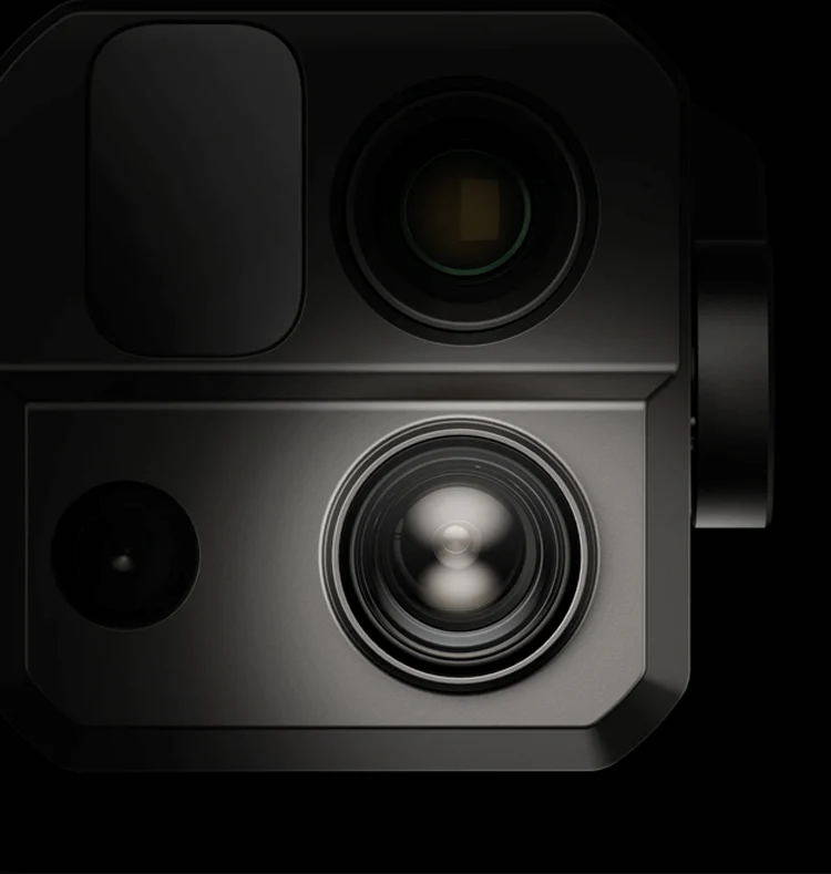
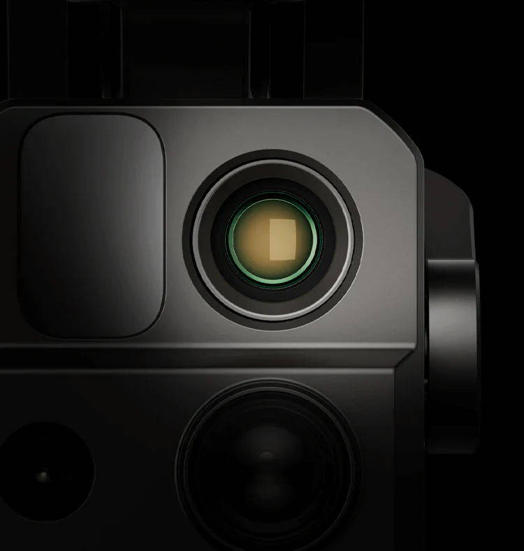
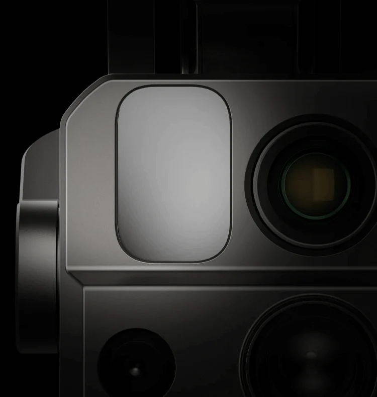
Mission Ready Payload
The payload integrates wide-angle camera, zoom camera, thermal camera and a laser rangefinder for all data capture needs and critical decision making.
50MP
Wide Camera
48MP
Zoom Camera
8K 10x
Optical Zoom
160x
Max. Hybrid Zoom
640x512
Thermal Resolution

Laser Rangefinder
Measuring Range:
5 - 1200m
Measurement Accuracy:
+1m
Laser Rangefinder
Measuring Range:
5 - 1200m
Measurement Accuracy:
+1m
Wide Camera
50MP
1/1.28" CMOS
Aperture: f/1.9
DFVO: 85°
Equivalent: 23 mm
Zoom Camera
48MP
8K 10x Optical Zoom
160x Max. Hybrid Zoom
Aperture: f/2.8-f/4.8

Autel Enterprise App Platform
The Autel Enterprise App is built from the ground up for industrial applications and features a brand-new interface for simple, efficient operation. Additional features and semi-autonomous modes maximize the EVO Max 4T's mission capability.

Smart Features
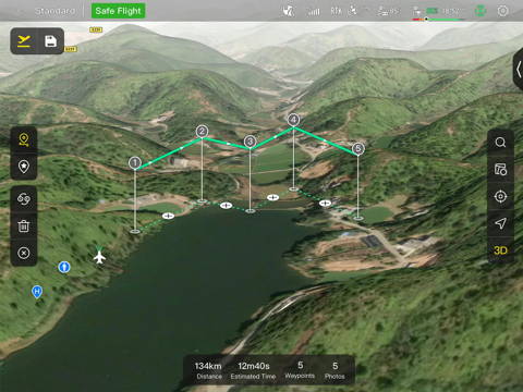
3D Map Planning
Plan, create, and execute 3D waypoint mission plan on a 3D map.

Quick Mission*
Temporary quick missions can be created while executing other missions, and multiple sub-missions can be stacked for enhanced flexibility.
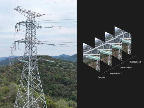
Mission Reproduction*
With this feature activated, fly a manual or semi-autonomous mission, or string multiple missions together. The EVO Max4T will automatically record the camera angles and replicate the mission you just flew.
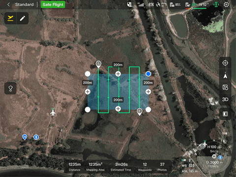
Polygon Mission
Supports one-click automatic generation of polygon flight areas.

Terrain Follow*
Maintain relatively constant altitude from the ground for uneven or sloped terrain.
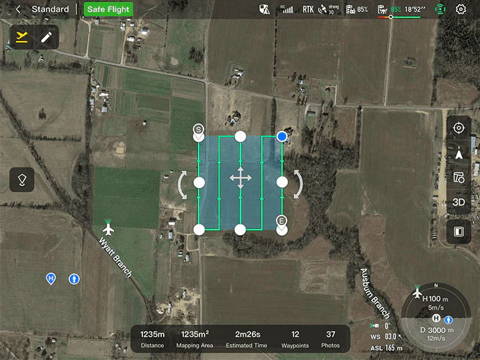
Rectangular Mission
Supports one-click automatic generation of a rectangular flight area.
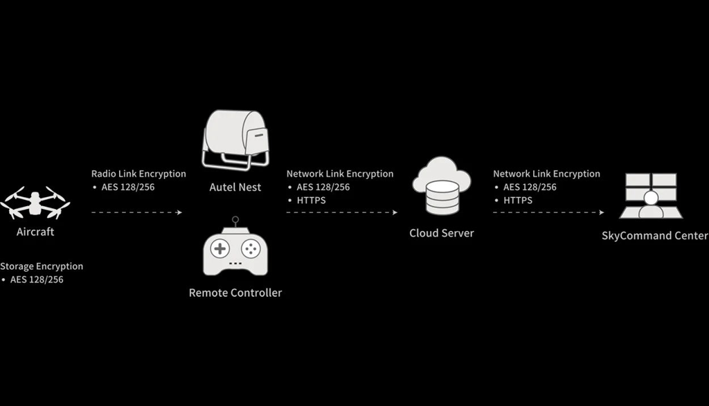
Data Security
Privacy Protection: Data involving user and aircraft information, including flight logs, locations, and account information can only be physically accessed via the aircraft locally.
Encrypted Data Storage: Supports AES-256 encryption for photos, videos, and flight logs, are password-protected.
Enhanced Live-View
Multi-channel Projection Screen*
Supports simultaneous output of RGB, infrared, night vision, and wide-angle images.
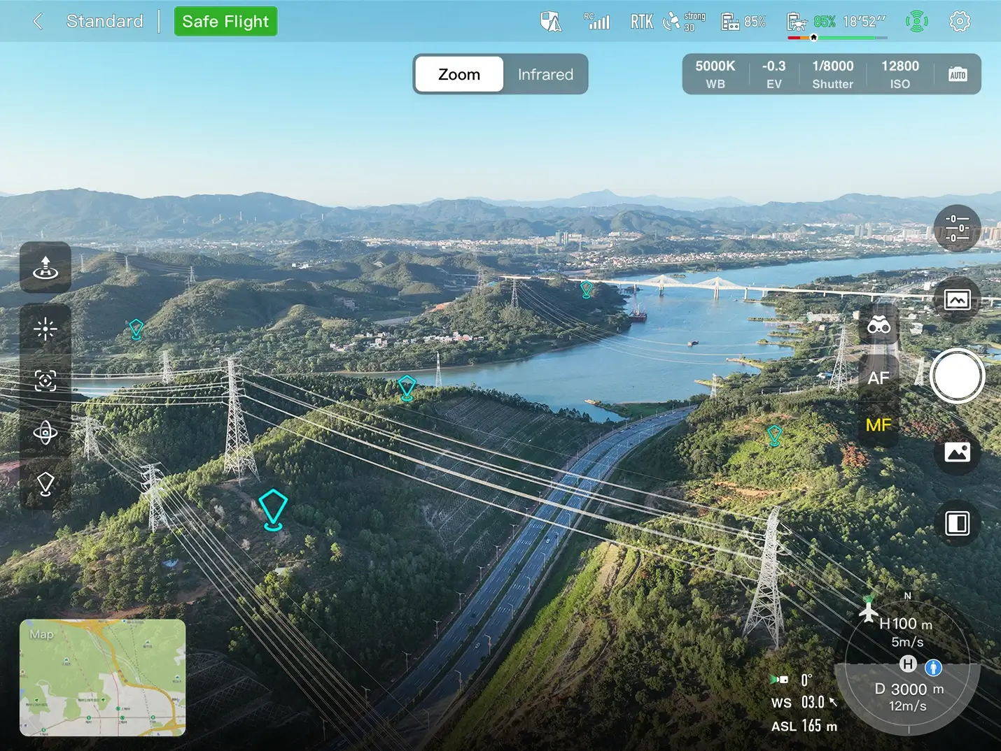
AR Scene*
Geo-location data and other aircraft location info detected by ADS-B can overlay on real-time map, which is convenient for users to confirm the drone's location and avoid airborne risks.

Autel SDK
The Autel SDK is open to the world, helping developers and partners reduce software and hardware development costs and jointly create a new industry ecosystem.
Mobile SDK
Open UX SDK (iOS&Android) can directly call up the ready-made interactive interface.

Payload SDK*
Unified interface standards support access to third-party mounts such as microphones and gas detectors.

Cloud SDK*
Enables remote live broadcast and control of drones and Nests through third-party platforms or web pages.
Accessories
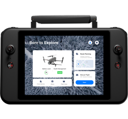
Autel Smart Controller V3
Daylight Readable Display: 7.9 inches, 2000nit maximum brightness, 2048*1536 resolution. SuperDownload: Download footage from drone to mobile device at a maximum rate of 20MB/s. Functional Interface: HDMI ports allow connection to 3rd party displays or monitors. Ultra-Long Battery Life: Up to 4.5 hours of continuous operation. 2-hr fast charging from empty. Local Storage: Built-in 128G storage space allows 3rd party apps and mission media storage.
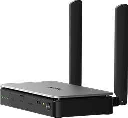
Live Deck 2 (optional)
Broadcast live mission intel to other personnel in the operation for enhanced situational awareness and critical decision making without the need for LTE connection. The EVO Max 4T is compatible with Live Deck 2, which offers multiport streaming to monitors and Wi-Fi support for multiple local smart phones.
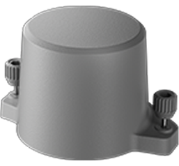
RTK Module (optional)
Provides centimeter-accurate positioning data for mapping and reduces electromagnetic interference for flying near critical structures.